Showing posts with label Typhoon Haikui. Show all posts

Wednesday, August 8, 2012

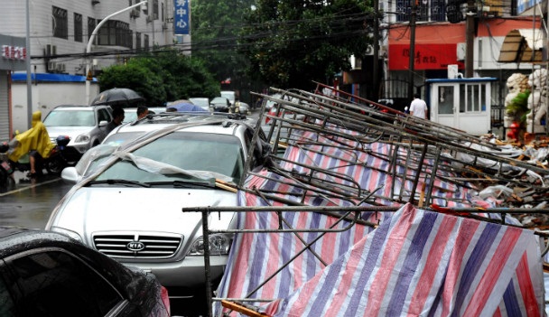
Typhoon Haikui strikes east coast of China


(CNN) -- Typhoon Haikui slammed into the east coast of China on Wednesday morning, pummeling the area around the business metropolis of Shanghai with heavy wind and rain.

The storm's winds were at "severe typhoon" strength when it made landfall in the province of Zhejiang, about 225 kilometers (140 miles) south of Shanghai, the China Meteorological Administration said. The winds diminished to typhoon strength as Haikui moved inland.

A severe typhoon is considered to have maximum sustained wind speed of between 150 and 184 kilometers per hour (93 and 114 mph). A typhoon has maximum sustained winds of between 118 and 149 kilometers per hour (73 and 93 mph).


Hundreds of thousands of people had been evacuated from Haikui's path as it approached, the third tropical cyclone to hit China's east coast in less than a week.

Chinese officials had relocated 374,000 people from Shanghai and 250,000 from Zhejiang, according to the state-run newspaper China Daily.

Although the storm's winds are expected to weaken as it moves overland, it will continue to dump large amounts of rain on the surrounding area, raising the risk of landslides and flooding.

"The rain is the bigger impact going forward," said CNNI Meteorologist Taylor Ward. "We have already had up to 8 inches in some locations."

Ward said another 6 to 10 inches of rain were expected to fall, with "maybe isolated amounts greater."

Haikui was moving northwest at 20 kph (12 mph) but was expected to slow over the coming two days, he said.

source: CNN


Floods again start to rise in Metro Manila amid heavy rains; Pagasa raises rain warning


MANILA, Philippines - Flood waters have again started to rise in key areas in Metro Manila as heavy rains resumed pounding the National Capital Region and nearby areas Wednesday afternoon.

Rains again started flooding Roxas Bolulevared in Pasay City, which seven days ago was submerged in hip-high floods due to a water surge.

Flood waters along the boulevard are deepest in areas near the Japanese Embassy, Central Bank of the Philippines, and Manila Hotel, and in Pasay City's F.B. Harrison.

Also, flood waters have started to rise on the road under Ayala bridge, Carlos Palanca Street in Makati City, and in Manila's Romualdez Street corner U.N. Avenue and T.M. Kalaw corner J. Bocobo Street.

At 3:30 p.m., the Philippine Atmospheric Geophysical and Astronomical Services Administration (Pagasa) raised the rain warning signal in the metropolis from yellow to green as the downpour intensified.

Again, after hourly rainfall increased to 17.82 meters at 4 p.m., Pagasa raised the warning to red, the highest in the three-color system.

Heavy to intense torrential rains are expected within the next two hours, according to Pagasa.

Meanwhile, Department of Justice Secretary Leila de Lima on Wednesday afternoon advised DOJ employees to go home due to the bad weather caused by "habagat" or southwest monsoon, which was earlier enhanced by Storm "Haikui."

source: interaksyon.com